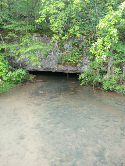
The Elk River begins at Burrough's Cove, in Grundy County, Tennessee. About 195 miles later, in Limestone County, Alabama, the Elk flows into the Tennessee River.
My work takes me to, and past some interesting places. One such place, is the beginning, or head, of the Elk River. Off Highway 50, to the left, just before going up the mountain to Altamont, is Burrough's Cove Road. Turn and go a half mile, the pull off is on the right, at the bridge.
I've been that way several times. On April 23, 2023, I stopped, and took some pictures.
This picture is from the bridge. The next two are from the bank. There are two cave openings. It was raining big drops that day. As the drops hit the water, the ripples were quickly carried downstream by the current. I was impressed with how fast they moved.
This last picture best shows the clean blue-green water flowing from the second cave opening.
Locals say some hard to believe things this about this spot:
"It's one of those Blue Holes. There is no bottom, it's so deep."
"Best water anywhere around, that's why they made moonshine out there."
And the best story I heard so far,
"A feller drove a team of horses and a wagon in there to get a drink. He got too close. Those horses and the wagon went off into that hole and never came out!"
The one about the moonshine is true. The other two, well...kinda hard to believe, but it makes for a good story.
The first thirty or so miles the Elk River meanders to the West, through farms, under country roads, and under interstate I-24. Once it travels under Prairie Plains road, it widens out and slows down. There is a boat ramp there. This is the beginning of Wood's reservoir. Here is a good picture of the Elk River at the Prairie Plains bridge.
Photo credit - and an interesting blog article about kyaking the Elk River, by Christov10, and more pictures
Wood's Reservoir information...
Wood's reservoir is a 3600 acre lake. The deepest spot is about 50 feet deep. Flowing through it, from start to finish is the Elk River.
At the southwest end of the lake is the dam. The Elk River begins again as the lake water is released through the gates. For ten or so miles, the Elk travels through woods, fields, and past houses. Once the river goes under Paynes Church Road, in Estill Springs, it widens out again. This is the beginning of Tim's Ford Lake.
Tim's Ford lake information:
At 10,700 acres, the surface area of Tim's Ford is three times the size of Wood's Reservoir. It is also about three times as deep, at 150 feet. The Elk River, and several other streams keep it full.
Interesting photos from before and during the construction of Tim's fORD. 16 minutes. "The Making of Tim's Ford Dam."
When that cold, clean water finally flows through the gates at the dam, it begins once again as the Elk River.
At this point, the Elk courses its way a hundred or so more miles, through Franklin, and Lincoln County and into North Alabama.
Photo credit - Pinterest, Citi-data.com Elkmont Al.
This photo shows the Elk river in Elkmont Alabama.
The Elk flows into the Tennesee River, about 195 miles from where it began, From this point on, the Elk River is not referred to again by name. Flowing now as part of the Tennessee River, it crosses North Alabama through the Wheeler, and Wilson Dams.
This link is to an interesting 16 minute video on the construction of Wilson Dam at Muscle Shoals, Alabama.
More information about the Tennessee River.
The Tennessee River flows North, back into Tennessee and Kentucky, before joining the Ohio River, in Paducah, Kentucky.
The Ohio River has a rich history, and is the third largest river in the United States, by volume of water.
More information about the Ohio...
On the Southern end in Cairo, Indiana, The Ohio River flows into the mighty Mississippi River.
One hundred miles south of New orleans, the Mississippi River flows into the Gulf of Mexico. The fresh water stays near the surface, over the more dense saltwater. Nasa photographs show the mixing of the two is not complete until the flow goes through the Gulf of Mexico, around the tip of Florida, and back up towards Georgia.
photo credit, and water flow into the gulf information credit: Jesse Allen, NASA Earth Observatory - http://earthobservatory.nasa.gov/Newsroom/NewImages/images.php3?img_id=17040, Public Domain, https://commons.wikimedia.org/w/index.php?curid=759630
Not too far out from the Georgia coast line, is the final mixing of Fresh and Salt water. Many miles down stream from Burrough's Cove, in Grundy County, Tennessee. The Elk River has long since given up it's name. Still, something of the Elk is there. Now hidden in the salty water of the Atlantic, the clean blue-green water from the cave, and those big rain drops from an April day remain.


